Berichten over uw Buurt
Zoals vergunningen, bouwplannen en lokale regelgeving
Open data of the government
Zoals vergunningen, bouwplannen en lokale regelgeving
Adressen en contactpersonen van overheidsorganisaties.
Dataset
| State | Available |
|---|---|
| Data owner | Gelderland (Provincie) |
| Updated | 02/27/2025 - 00:00 |
| License | Publiek domein |
| Thema |
|
| Publicity level | Public |
| Metadata | Download (XML/RDF) |
You can do a datarequest to request a specific dataset.
Make a data request
Dit gebied omvat een zone van 250 meter rondom zeer gevoelige natuur in het Gelders natuurnetwerk waar de emissie van ammoniak niet mag toenemen bij uitbreiding van niet-grondgebonden veehouderij. Dit bestand is vastgesteld door Provinciale Staten op 1 maart 2017.
No feedback found.
You can do a datarequest to request a specific dataset.
Make a data requestDit is een grafische representatie van de dataset die via het NationaalGeoregister.nl aangeboden wordt.
Het is mogelijk dat deze grafische representatie geen weerspiegeling van de data is, maar dient als ondersteunende afbeelding. Indien de dataset via een OGC:WMS service aangeboden wordt, is het mogelijk om zelf een grafische weergave van de dataset te genereren.
Source: https://geodata.gelderland.nl/bestanden/geo-teksten/Metadata/bitmap/POVE_Ammoniakbuffergebied.png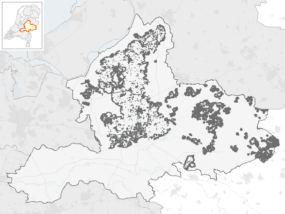
https://geoserver.gelderland.nl/geoserver/ngr_verordening/wms?service=WMS&request=GetCapabilities
accessPoint
https://geoserver.gelderland.nl/geoserver/ngr_verordening/wfs?service=WFS&request=GetCapabilities
accessPoint
accessPoint
No feedback found.