Berichten over uw Buurt
Zoals vergunningen, bouwplannen en lokale regelgeving
Open data of the government
Zoals vergunningen, bouwplannen en lokale regelgeving
Adressen en contactpersonen van overheidsorganisaties.
Dataset
| State | Available |
|---|---|
| Data owner | Gelderland (Provincie) |
| Updated | 27-02-2025 |
| License | Publiek domein |
| Thema |
|
| Publicity level | Public |
| Metadata | Download (XML/RDF) |
Then click the "Get help with searching" button.
Get help with searching
In dit bestand wordt provincie Gelderland opgedeeld in landschapstypen. In totaal zijn er 17 verschillende typen: o.a. bos, heide-, essen-, kampen-, veenontginningslandschap. Dit bestand is opgesteld en gebruikt ten behoeve van het Streekplan 1996 dat op 25 september 1996 is vastgesteld door Provinciale Staten.
No feedback found.
Then click the "Get help with searching" button.
Get help with searchingDit is een grafische representatie van de dataset die via het NationaalGeoregister.nl aangeboden wordt.
Het is mogelijk dat deze grafische representatie geen weerspiegeling van de data is, maar dient als ondersteunende afbeelding. Indien de dataset via een OGC:WMS service aangeboden wordt, is het mogelijk om zelf een grafische weergave van de dataset te genereren.
Source: https://geodata.gelderland.nl/bestanden/geo-teksten/Metadata/bitmap/Ls_Landschapstypen_1850.png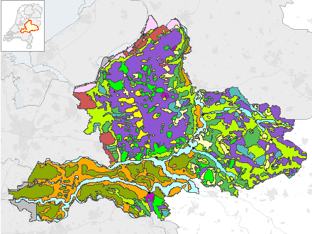
https://geoserver.gelderland.nl/geoserver/ngr_b/wms?service=WMS&request=GetCapabilities
accessPoint
https://geoserver.gelderland.nl/geoserver/ngr_b/wfs?service=WFS&request=GetCapabilities
accessPoint
No feedback found.